Best practices
The following is a list of general advice on how to help your module interact seamlessly with other workflows. Although not obligatory, Core modules should strive to comply with these guidelines.
Metadata recommendations
The structure of the configuration, user provided resources, and module results should be clearly structured. Here are some general recommendations on how to achieve this.
Embedded metadata
When possible, save important metadata within files instead of producing separate ones.
This can vary from adding a source column to a table, to adding metadata to a file's attributes.
The following metadata values are often useful:
units: a dictionary specifying per-column units, usingno_unitfor unitless cases.source: a string specifying the source and/or author of a dataset.license: a string specifying the license of the dataset.
Example: embedding metadata with pandas
pandas will automatically convert data in df.attrs into file-level metadata when saving to .parquet:
Consistent naming
Follow these principles to avoid confusion and reduce the need for extensive documentation.
- Naming convention: use snake_case (
foo_bar) for columns, configuration keys, file names, parameters, etc. Avoid hyphens (foo-bar) and camel case (FooBar). - Prefer explicit names over implicit ones: A value's purpose should be clear from its name. For example, use
longitudeandlatitudeto represent a position rather than ambiguous labels such asxandy. -
Ensure units are explicit: configuration values and file attributes should state units explicitly in their naming.
-
Use consistent country / subregion identifiers: do the following when dealing with national and sub-national identification codes.
- Country identifiers: national IDs should be under the
country_idkey and follow ISO 3166-1 alpha-3 (e.g., CHE, CHN, GBR, MEX, etc). - Subnational region identifiers: identifiers related to (sub)national regions/polygons should be under the
shape_idkey. This applies even in cases where national resolution is requested (i.e.,country_idandshape_idshould match).
Example: table with country and subnational identifiers
country_id shape_id demand_mwh DEU DE13 4500 DEU DE14 4800 ITA ITA0 20000 - Country identifiers: national IDs should be under the
-
Standardise currencies: currency codes must follow ISO 4217 alpha-3 codes in combination with the year of the currency (e.g., CHF2024, EUR2015, USD2020) to allow for clear currency adjustments.
Timeseries recommendations
Timestamp ISO standard
Follow ISO 8601 specifications and ensure timeseries include UTC date and time (e.g., 2026-07-15 12:00:00+00:00) specifications to avoid time interval issues.
Example: convert timeseries to UTC with pandas
# if the timeseries is already recorded in UTC.
df["timestamp"] = pd.to_datetime(df["timestamp"], utc=True) # (1)!
# if the timeseries was recorded for a different timezone
df["timestamp"] = (
    pd.to_datetime(df["timestamp"])
    .dt.tz_localize("Australia/Sydney")  # (2)!
    .dt.tz_convert("UTC")
)
- Non-ISO (UTC) -> ISO (UTC)
- Non-ISO (Sydney) -> ISO (Sydney) -> ISO (UTC)
Time period standard
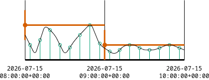
As a general convention, we interpret timestamp periods in a start-of-period fashion. E.g. 00:00 should be the first timestep of the day (covering from 0:00 until 00:59), and 23:00 the last (from 23:00 to 23:59).
Timeseries generally represent parameters that are either instantaneous or computed. Our start-of-period convention applies to both cases.
-
Instantaneous parameters: these represent the value at exactly the specified timestamp.
Example: instantaneous samples
Imagine we are sampling temperature using a sensor in a periodic fashion at 1-hour intervals.
Assuming instantaneous sampling, the 09:00 timestamp would represent the parameter at exactly 09:00.

-
Computed parameters: these represent the result of an operation over a collection of instantaneous samples. This could be a cumulative sum, mean, maximum, minimum, etc.
Example: computed maximum
Assume our parameter is the computed maximum temperature over a period of 1-hour.
Under a start-of-period convention, the 08:00 value would represent the maximum from 08:00 to 09:00.
Adjusting end-of-period timeseries
Some datasets and tools, such as ERA5 reanalysis dataset and the atlite library provide data in an end-of-period fashion.
Adjusting to start-of-period is trivial with pandas.
- Assumes the data already has a
DatetimeIndex.
Configuration recommendations
These recommendations relate to the configuration files provided by users (config/config.yaml).
Extra validation
Configuration YAML files should always be validated to detect invalid user settings using the latest JSON-schema specification. However, it might be necessary to write additional tests to catch problems that regular JSON-schema logic cannot guard against. You can write these tests in a separate validation function.
include: "rules/_utils.smk" # (1)
configfile: workflow.source_path("../config/config.yaml")
validate(config, workflow.source_path("internal/config.schema.yaml"))
additional_validation(config)  # (2)
- Defines
additional_validation. - Used for validation checks with more detailed logic.
Common structures
Here are some recommended structures for configuration settings commonly needed by modules.
-
Coordinate reference systems: request users to specify their CRS of choice, and group these under the
crskey.- Geographic operations where preserving position matters.
- Projected operations where preserving distance or area matters.
-
Temporal scopes: if your module supports a flexible temporal scope, define the date range using an inclusive start date and an exclusive end date.
The range below includes data from
2017up to, but not including,2020(i.e., 2017, 2018, and 2019).- Will be included in data.
- Won't be included in the data.
Tabular file recommendations
These recommendations relate to tabular data consumed / produced by modules.
Storage format
We highly recommend the use of Apache Parquet (.parquet) over other formats (such as .csv).
- Very good read/write performance.
- High storage efficiency and metadata compatibility.
- Supports geospatial data thanks to the Geoparquet standard.
Tidy data principles
We also recommend to follow tidy data principles to make data machine-readable (prefer "long" tables over "wide" ones when applicable).
Example of a tidy table
| year | country_id | shape_id | demand_mwh |
|---|---|---|---|
| 2020 | ITA | North | 4500 |
| 2020 | ITA | East | 4800 |
| 2020 | ITA | South | 3000 |
Validation
As stated in our Convention, modules should validate inputs whenever possible. In the case of tabular data, we highly recommend to also validate intermediate tabular files produced by the module.
pandera DataFrame models offer a simple, pragmatic way to achieve this.
Validating input shapes
Input shape files, a.k.a. (sub)national regions are a common input to many modules. Below you can find a simple schema that follows the structure of the Geo-boundaries module.
from pandera import pandas as pa
from pandera.typing.geopandas import GeoSeries
from pandera.typing.pandas import Series
from shapely.geometry import MultiPolygon, Polygon

class ShapesSchema(pa.DataFrameModel):
    """Schema for geographic shapes."""

    class Config:
        coerce = True  # (1)!
        strict = "filter"  # (2)!

    shape_id: Series[str] = pa.Field(unique=True)
    "A unique identifier for this shape."
    country_id: Series[str] pa.Field(str_length=3)
    "Country ISO alpha-3 code."
    shape_class: Series[str] = pa.Field(isin=["land", "maritime"])
    "Identifier of the shape's context."
    geometry: GeoSeries

    @pa.check("geometry", element_wise=True)
    def check_geometries(cls, geom) -> bool:  # (3)!
        return (
            isinstance(geom, (Polygon, MultiPolygon))
            and not geom.is_empty
            and geom.is_valid
        )
- Attempt to coerce values before raising failures.
- Remove columns not specified in the schema.
- Check that input geometries are healthy.
Other GIS file formats
These recommendations relate to non-vectorised GIS files.
Raster data
For raster data we recommend to use GeoTIFF (.tiff, .tif) files.
When possible, users should rely on Cloud Optimised GeoTIFF (COG) files, which allow downloads of specific spatial extents, saving download bandwidth.
Gridded data
For gridded data we prefer to use netCDF (.nc) files.
We recommend to follow similar conventions as the atlite library, where coordinates represent points in the center of each grid cell.